Terrain
Continuing from part 2, a scalable fractal method is used to create terrain. All attributes generated is based on a specific seed for the current region.
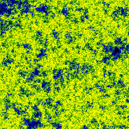
An example of terrain elevation (black / blue: low, green / yellow: high), and using a threshold to define land (green) / water (blue)
Humidity / Rainfall
Continuing to a more advanced scenario, humidity / rainfall could be determined from obvious sources, any bodies of water. In this case, a streight forward approach is used, using a Gaussian function / filter.
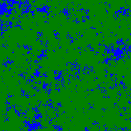
Humidity / rainfall map (blue: humid, yellow: dry)
Temperature
Temperature can be generated by using a similar algorithm used for the terrain, and subsequently applying a Gaussian filter. As mentioned, all the attributes for this region are based on a single seed. This means that for each map or set of attributes, random generators are reset to the start seed. Generating this secondary map for temperature would result in a geography identical to the terrain map. This is resolved by offsetting the generation by 1 or more draws.
for (loop = n)
{
random()
}
// proceed with random draws from terrain
It was found that a single draw is enough so the resulted maps show no similarity with previous generated maps based on the same seed.
Additionally, this map can be adjusted for water and elevation. Above water temperature is moderated, reducing very low or very high temperatures towards a baseline value. For land, the temperature is reduced by the elevation level.
Temperature map (red: hot, blue: cold)

We now have elevation, humidity and temperature. Using composite coloring, these can be combined into a single map. But first, lets look at defining biomes.
Biome
As final step, biome type can be defined. The biome type can be determined as function of temperature and rainfall.
In the composite map, the temperature is shown using the red / blue color channels as in the temperature map, and humidity / rainfall is indicated using the green color channel. Water is shown as plain blue.
Using a mapped coloring scheme, the biome types can be visualised on the same map.
Composite map / Biome map

Links
Generating Random Fractal Terrain